Introduction
The Big Levels plateau
rises somewhat over a thousand feet (300 m) above the alluvial fans
at its base. The dominant rocks are Lower Cambrian Antietam
quartzites and sandstones and Hampton Formation, consisting of
siltstone, subgraywacke and qurtzose sandstone (Werner, 1966; Rader
and Evans, 1993), The quartzites, which are most conspicuous, are
dense, gray in color, coarsely crystalline and massively bedded.
Consequently they are highly resistant to both chemical weathering
and erosion. In most places bedrock is covered by coarse regolith
derived from it and ranging in element size from silt to large
quartzite blocks. Despite its resistant nature, the Antietam was
eroded through the millennia by streams and deposited as alluvial
fans, which ring the plateau on the northwest, north and northeast
(Kochel and Simmons, 1986). These geological features illustrate the
differences between the western Blue Ridge, in which they occur, and
the eastern Blue Ridge, which is comprised of far older Pre-Cambrian
rocks with more complex lithologies that gave rise to richer soils
and support more diverse floras. The nature of the flora and certain
aspects of the fauna associated with the alluvial fans are discussed
in our section on Maple Flats.
Stony
Run Jeep Trail to Big Levels
Source Walk: 10-30-94
Stony Run descends almost directly north from the Big Levels Plateau,
and the jeep trail ascends a spur a little to the east. The entire
route, which contains eight switchbacks, is in part over Antietam
sandstones and in part over Hampton rocks, apparently of similar
nature. Soils are very stony and quite sandy. Only two springs were
seen along the nearly four mile (6.4 km) route to the top. On this
day the weather was warm, mostly clear and pleasant, Katydids called
and ants were very active. We saw few birds, including a few Juncos
(Junco hyemalis ) and a single woodpecker, likely a Hairy
(Picoiodes villosus).
Elevation at Coal Road, the start of our ascent, is ~1900 feet (580
m) asl, and the canopy consisted of Chestnut and Scarlet Oaks
(Quercus prinus and Q. coccinea), Pitch Pine (Pinus
rigida), Black Gum (Nyssa sylvatica), Sassafras
(Sassafras albidum), Red Maple (Acer rubrum ),
Black Locust (Robinia pseudoacacia) and Virginia Pine
(Pinus virginiana), while American Chestnut (Castanea
dentata) sprouts and Mountain Laurel (Kalmia latifolia)
formed an understory of sorts.
Noted initially along the trail were Upland Low Blueberry (Vaccinium
pallidum), Trailing Arbutus (Epigaea repens), common
Bracken Fern (Pteridium aquilinum), clumps of Crinkly
Hairgrass (Deschampsia flexuosa ), Stiff Aster (Aster
linariifolius) and Moonbeam (Coreopsis verticillata).
Soon we also began to see Bear Oak (Quercus ilicifolia ) and
dead pines, possibly killed by the Southern Pine Beetle
(Dendroctonus frontalis).
After the first right turn in the trail we saw serviceberry, likely
Downy (Amelanchier arborea) under a canopy as first
described, and along the trail Pasture Rose (Rosa carolina)
with large red fruits as well as an unidentified goldenrod (Solidago
sp). After a sharp right turn, the first Black Oak (Quercus
velutina) was noted. Then after a sharp left turn at near 2100
feet (640 m) asl, we encountered the- likely-Hairy Woodpecker and
a few clumps of Spotted Wintergreen (Chimaphila maculata
). An unidentified species of the moss genus Leucobryum
occupied the trail bank, while a dung beetle, also of unknown
species, was occupied with horse dung on the trail itself.
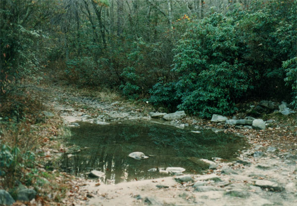
Now, at another left turn at ~2200 feet (727 m) asl, there was a
small drainage with water, and nearby several Northern Red Oak
(Quercus rubra) and some blackberries (Rubus sp) of
unknown species. Here also was Sweet Fern (Comptonia peregrina)
and Wiry Ground Cedar (Lycopodium tristachyum ). This
clubmoss, so characteristic of dry acid habitats, became more
frequent above this level. The canopy here was still dominated by
Chestnut Oak, with Pitch and Virginia Pines, and now also with Table
Mountain Pine (Pinus pungens). We also began to see the
widely spaced multiple sprouts of Chestnut Oak that are
characteristic of fire-killed trees.
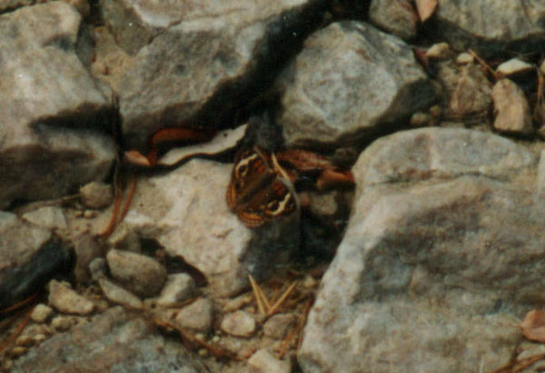
As our climb continued, patches of haircap moss (Polytrichum
sp) began to appear, as did an unidentified legume, possibly the
non-native Hairy Vetch (Vicia villosa). After a turn to the
right at ~2400 feet (730 m) asl, the forest became very scrubby,
with many of the multiple-sprout Chestnut Oaks. Wiry Ground Cedar
appeared to increase as well, and a little higher an unusual
butterfly was seen resting on a trail rock.
Now at ~ 2480 feet (756 m) asl, and after a sharp right turn, Pitch
Pine with a Mountain Laurel understory dominated, there was abundant
Wiry ground Cedar, and an unidentified dung beetle was again seen
near horse manure in the trail.
After a sharp left turn we encountered our first Minnie-bush
(Menziesia pilosa ), a seedling of Canada Hemlock (Tsuga
canadensis), Black Birch (Betula lenta) and Catawba
Rhododendron (Rhododendron catawbiense )-one of each.
Somewhat higher the Mountain Laurel assumed a particularly lush
appearance and was accompanied by more Minnie-bush. Here also there
were the weathered remains of an iris of unknown species. Upland low
Blueberry, Trailing Arbutus, Bracken Fern (the only fern) and Wiry
Ground Cedar continued to be abundant along the trail, and these were
now joined by Black Huckleberry (Gaylussacia baccata).
After a sharp right at ~2650 feet (800 m) asl and conspicuous
Catawba Rhododendron, we noted a Cladina lichen of an
unidentified species and a number of very large (~ 2 meter diameter)
ant hills that were populated by ants with a red thorax and a black
abdomen. It seems likely that the hills were so large as a
consequence of the high rock content of the soil. More of these large
ant hills were seen after another sharp left turn at ~2840 feet (870
m) asl.
After a sharp right at 2920 feet (890 m) asl, there was a
conspicuously stunted forest of Chestnut Oak, Pitch Pine, Black Gum,
Mountain Laurel and Black Huckleberry. Thus far Trailing Arbutus had
been common, but there had been no sign of its frequent associate,
Teaberry (Gaultheria procumbens), However here this plant
suddenly put in an appearance in association with Catawba
Rhododendron.
As we topped out at approximately 3100 feet (950 m) asl, there was
an explosion of Teaberry, and Catawba Rhododendron became more
abundant as well. Now moving along an almost flat path, the
surrounding oak forest exhibited a ground cover of almost continuous
Teaberry, while Trailing Arbutus and Wiry ground Cedar appeared to
have dropped out. Farther on we encountered a few White Pine (Pinus
strobus) and seedlings of Hemlock, with the latter showing no
sign of the Hemlock Woolly Adelgid (Adelges tsugae) that
has destroyed so many Hemlock in the Appalachians. It is noteworthy
that this site lies only a few hundred feet in elevation above the
Hemlock stands of the adjacent Johns Run, stands which has been
devastated by this insect. Here also katydids were heard calling.
Continuing over the gently sloping Big Levels, we encountered a
single bush of Black Chokeberry (Aronia melanocarpa), and
a little farther on the first specimen of the Appalachian endemic
shrub Mountain Fetterbush (Pieris floribunda), and here a
minor component with Mountain Laurel. Also, in this essentially
ericaceous Chestnut Oak forest with Black Gum, Catawba Rhododendron
remained important in association with Laurel, and Teaberry, with
very large and abundant berries, formed virtually the only ground
flora.
Wiry Ground Hemlock and Trailing Arbutus were also minor components
in this forest, and we here saw our first Deerberry (Vaccinium
stamineum), with possible Upland Low Blueberry. The latter still
had berries, somewhat glaucous and desiccated, but sweet. Since these
berries appear to have ripened late in the season and were glaucous,
they may represent the closely related Late Low Blueberry (Vaccinium
vacillans ). However it appears that the two species
(or varieties!) may also be gradational into each other
(Strausbaugh and Core, 1977). Additionally, American Chestnut sprouts
and Pitch Pine were quite common, and there were scattered White Pine
and healthy-appearing small Hemlock.
We had now reached the spring which forms the head of John's Run, and
which was considerably degraded by the jeep trail. However, both
Rhododendron and Laurel were relatively luxuriant here, and a little
beyond the spring we saw our first Tree Clubmoss (Lycopodium
obscurum).
Continuing up-trail, Bear Oak, Black Gum and Trailing Arbutus became
more common, a Raven (Corvus corax) was heard calling, and
a large gray-brown cricket was observed feeding on a katydid.
It should be mentioned that the unidentified serviceberry mentioned
earlier, and/or perhaps other species of the genus, were observed
scattered throughout the area traversed in small numbers at all
elevations.
As we retraced our steps to Coal Road we added Little Bluestem
(Andropogon scoparius) and Virginia Strawberry (Fragaria
virginiana) to our tally of plants. Also bats of unidentified
species were observed over the road.
Bald
Mountain Trail to Green Pond
The Bald
Mountain Trail begins near the Bald mountain overlook on the Blue
Ridge Parkway approximately 5 airline miles (8 km) SE of the Stony
Run crossing of Coal Road that appears in the previous section. From
there it leads north roughly 4 trail miles (6.4 km) to Green Pond,
which lies immediately east of the head of St. Marys River.
Elevations along the route are well above 3000 feet (915 m), with
bald mountain at 3568 feet (1088 m) asl. Green Pond lies at near
3200 feet (976 m) asl. Bedrock along the route is at first Hampton
Formation, then Antietam Formation. Green Pond is developed in a
gravelly, loamy sand residuum several meters in depth, which overlies
the quartzite, and the pond is really a sphagnum bog underlain by
several feet of peat (Whittecar and Lawerence, 1999). The water
level of Green Pond varies greatly and the Pond generally lacks
standing water in dry periods.
Source Walk:
10-13-91
The xeric and
ericaceous nature of the forest along the route was immediately
apparent. Oaks noted were Chestnut, Scarlet, Black, Northern Red and
White. These were accompanied by Red Maple, Black Gum and Pitch and
Table Mountain Pines. Understory and shrub layers included Striped
Maple (Acer pensylvanicum), an unidentified serviceberry
(Amelanchier sp), Catawba Rhododendron, Mountain Laurel,
Minnie-bush, Black Huckleberry and a little Red Elderberry (Sambucus
pubens). In few places there is also richer and more mesic
forest in which American Basswood (Tilia americana) was
observed.
On arrival at Green
Pond we noted that it consisted largely of a sedge meadow with
Sphagnum between the sedges. The surrounding forest in the immediate
vicinity of the sedge meadow was dominated by Pitch Pine, with
various oaks and Red Maple and edged by rhododendron (likely Catawba
Rhododendron), huckleberry (likely Black Huckleberry). Black
Chokeberry, Mountain Laurel and a greenbrier (likely Common
Greenbrier / Smilax rotundifolia ).
The forest surrounding
the Pond had one of the heaviest growths of Teaberry ever seen by
this reporter, and this plant formed an almost continuous ground
cover. Also, this plant was very abundant in this part of the Plateau
quite generally.
The entire area of the
Plateau was also heavily impacted by the Gypsy Moth (Lymantria
dispar), and there were numerous egg masses on the tree trunks.
Source walk: 10-17-93
First noted on
our traverse was the large number of Gypsy Moth -killed oaks. However
there appear to have been few Moths the past season, since many oaks
still had undamaged leaves and the trees appear to be recovering.
Interestingly, its bright leaf colors at this time allowed a more
accurate than usual estimate of the abundance of Black Gum in this
forest. The land surface along the route was characterized by
relatively sterile-appearing, rocky, rubble-covered terrain in which
Antietam, or Antietam type quartzite blocks have a prominent role.
Noted along the trail
were the following asters: Big-leaf Aster (Aster macrophyllus),
Mountain Aster (Aster acuminatus), Blue Wood Aster
(Aster cordifolius), Purple-stem Aster (Aster puniceus),
Hairy Aster (Aster pilosus) and Smooth Aster (Aster
laevis). It is of interest that none of these were observed at
Maple Flats (see our section on the latter). Other species
successively tallied were Tree Clubmoss (Lycopodium obscurum),
Wild Sarsaparilla (Aralia nudicaulis), Mountain Holly
(Ilex montana), possible Upright Yellow Wood Sorrel (Oxalis
stricta), Yellow False Foxglove (Aureolaria flava),
Starry Campion (Silene stellata) in bloom, Woodland
Sunflower (Helianthus strumosus), Hairy-jointed Meadow
Parsnip (Thaspium barbinode), an unidentified ricegrass
(Oryzopsis sp), Scarlet Oak, Indian Tobacco (Lobelia
inflata), an unidentified muhly grass (Muhlenbergia sp),
an unidentified hairgrass (Deschampsia sp) and the
shrubby Orangegrass (Hypericum gentianoides). Mountain
Aster is a northern species usually confined to cold habitats in the
Appalachians.
A
Wood Frog (Rana sylvatica }was also seen along the route.
Arriving at Green
Pond, we found it again to lack standing water. Prominent, in
addition to the shrubs identified on our 10-13-91 visit, was Button
Bush (Cephalanthus occidentalis), which, however grew
farther toward the Pond center, as it is more aquatic than the other
shrubs. Also observed was the concentration of Black Chokeberry,
Button Bush, blueberry (species unidentified) and huckleberry
(species unidentified) on the Ponds north side, and Catawba
Rhododendron on the south side. Other plants identified were
Three-way Sedge (Dulichium arundinaceum) and Marsh St.
Johns-wort (Hypericum virginicum or Triadenum
virginicum). According to the Virginia Natural Heritage Program,
Green Pond is the only Virginia station for the rare sedge Carex
aquitilis, and this plant is said to be the dominant graminoid
at the Pond. However, it was missed by us.
A plant of some
interest on the Pond's south side was Large Cranberry (Vaccinium
macrocarpon ), which in this case, however, had been planted
(Hanrenkrat, 1980). Nonetheless, it seemed to be thriving in the open
sedge meadow, in the shade of the trees at the Pond edge, and had
numerous large ripe berries on this day.
Fauna observed in the
vicinity of the Pond included a beautiful American Toad (Bufo
americanus) and a large falcon, Likely a Peregrine (Falco
peregrinus), that flew directly over the Pond.
John's Run
Source Walk: 7-3-94
John's Run descends,
almost directly north, from the Big Levels Plateau, in a deep ravine
just east of Stony Run. Most of the John's Run mainstem and the
adjacent slopes are underlain by Hampton Formation (Werner, 1966)
and there are many fewer seeps and wetlands than there are along
Kennedy Creek.
The first part of the
traverse was through dry, acidic forest except immediately next to
the stream. The dry upland forest had a canopy of Chestnut, Scarlet,
Black and some Northern Red Oak, as well as Black Gum, Sassafras, Red
maple and Pitch Pine. Undergrowth included Mountain Laurel, Black
Huckleberry, Maple-leaf Viburnum (Viburnum acerifolium),
Deer Berry and low blueberry, likely upland Low (Vaccinium
pallidum), which was beginning to form fruit.
Near the stream were
Tuliptree (Liriodendron tulipifera), Black Birch,
Minnie-bush, Maleberry (Lyonia ligustrina), Fringe Tree
(Chionanthus virginicus), Smooth Alder (Alnus serrulata),
Wild Raisin (Viburnum cassinoides ), Highbush Blueberry
(Vaccinium corymbosum) and Flowering Dogwood (Cornus
florida ).
Herbs characteristic
of the dry forest were Greater Tickseed (Coreopsis major)
and Moonbeam, both in full bloom, Goat's Rue (Tephrosia
virginiana), Trailing Arbutus, Teaberry, an unidentified iris,
Rattlesnake Weed (Hieracium venosum), a creeping five-leaf
(Potentilla sp), Wild Indigo (Baptisia tinctoria),
Long-leaf Summer Bluet (Houstonia longifolia),
Stiff Aster (Aster linariifolius), Yellow Stargrass
(Hypoxis hirsuta), Bracken Fern (Pteridium aquilinum ),
Partridge Berry (Mitchella repens) and White Wood Aster
(Aster divaricatus).
Progressing up-stream,
the forest became more mesic and perhaps less acidic, although
Partridge Berry remained common everywhere. Farther up-stream, at
perhaps 2000 feet (600 m) asl, small patches of Sphagnum moss
appeared, and there were scattered Wild Sarsaparilla and Mountain
Aster, indicators of a cool climate. At about 2500 feet (760 m) asl
these species were among the ground flora dominants. Of interest also
was the presence, beginning at low elevations, in seepy areas, of the
rare herb Swamp Pink (Helonias bullata ), identified from
the character of its leaves.
Above 2000 feet asl
Northern Red Oak increased greatly in numbers, and small Hemlock that
had lost most of their foliage to the Adelgid were conspicuous.
Present also, were some very large Tuliptrees and the first Yellow
Birch (Betula alleghaniensis) was noted, while Black Birch
became more common. Also noted were Black Locust, American Chestnut
sprouts, Witch Hazel (Hamamelis virginiana) and an
unidentified serviceberry. Catawba Rhododendron also put in an
appearance but was not prominent. Vigorous Common Greenbrier, Spice
Bush (Lindera benzoin) and Cinnamon Fern appeared in moist
areas, where Sphagnum moss became more common. Indian Cucumber-root
(Medeola virginiana) also appeared to increase with
elevation. New York Fern (Thelypteris noveboracensis)
was the dominant ground cover in many places here, as it also had
been at lower elevations, and Christmas Fern (Polystichum
acrostichoides) marked richer soil areas. Common Speedwell
(Veronica officinalis ) also occurred but was not as
widespread as Partridge Berry. Also observed in and along the trail
were a chanterelle (Cantharellus sp) mushroom, the leaf
rosette of the Pink Ladyslipper (Cypripedium acaule),
four-leaved Yam (Dioscorea quaternata), Cow Wheat
(Melampyrum lineare) and an unidentified violet. Also seen
were a few seedlings of White Ash (Fraxinus americana), but
not a trace of American Beech (Fagus grandifolia) or
Sugar maple (Acer saccharum).
Farther up-valley we
came upon a single Butternut (Juglans cinerea), Virginia
Creeper (Parthenocissus quinquefolia), Dutchman's Pipe Vine
(Aristlochia macrophyllus), May Apple (Podophyllum
peltatum), and Plume Lily (Smilacina racemosa).
At near 2400 feet
(732 m) the first Striped Maple was seen, and Round-leaf Violet
(Viola rotundifolia) was common under Hemlock and near
the stream. Spotted Wintergreen (Chimaphila maculata)
was also part of the upland ground flora. There was also a
non-blooming and hence unidentified member of the lily family,
perhaps a species of the genus Uvularia or Polygonatum.
Birds seen and / or
heard here included Scarlet Tanager (Piranga olivacea),
Wood Thrush (Hylocichla mustelina) and Pileated Woodpecker
(Dryocopus pileatus).
As the stream's
headwater region was approached at ~ 2600 feet (790 m), Striped
Maple, Wild Sarsaparilla and especially Mountain Aster became more
common. There was old growth forest here dominated by Hemlock, now
almost defoliated by the Adelgid, Northern Red Oak, Black and Yellow
Birches and Tuliptree. Striped Maple, Mountain Holly, Catawba
Rhododendron and Witch Hazel formed an undergrowth, while the ground
flora consisted of Partridge Berry, Mountain Aster, Indian
Cucumber-root, Round-leaf Violet and Intermediate Shield Fern
(Dryopteris intermedia).
On our return trip
some additional species noted in the upland forest were Wood Betony
(Pedicularis canadensis), Bear Oak and evidence of
Blackjack Oak (Quercus marilandica) in the form of leaves
with the diagnostic form.
Acknowledgements
Particular credit is
due to Dr. Robert Hunsucker for his identification of a number of the
plants encountered in these inventories. Also, the participation of
Steve Krichbaum and Mike Jones in the inventories is greatly
appreciated. As always we greatly appreciate the faithful financial
assistance of Patagonia Corp. and our fiscal sponsor Save America's
Forests.
References
Hanrenkrat, F. (1980)
Mystery Bog: The origin of this quaking bog remains an enigma.
Virginia Wildlife, 11; 16-17.
Kochel, R. Craig and
David W. Simmons (1986) Quaternary Alluvial Fans in Central
Virginia, pp 123-126, in The Quaternary of Virginia, a
Symposium Volume, J. N. McDonald and S. O. birds, editors. Dept.
of Mines, Minerals and Energy, Virginia Dept. of Mineral Resources,
Charlottesville, Virginia.
Rader, E. K. and N. H.
Evans, editors (1993) Geologic Map of Virginia, expanded
explanation. Virginia Div. of Mineral Resources, Charlottesville,
Va.
Strausbaugh, P. D. and
E. L. Core (1977) Flora of West Virginia, 2nd edition.
Seneca books Inc, Grantsville, West Virginia
Werner, H. J. (1966)
Geology of the Vesuvius Quadrangle Virginia, Report of
Investigations 7. Virginia Division of mineral resources,
Charlottesville, Virginia.
Whittecar, G. Richard
and James R. Lawrence (1999) Hydrology and Geomorphology of Green
Pond- a High-elevation Depressional Wetland in the Blue ridge of
Virginia. Banisteria 13, 149-159.