The following article was originally published in 1991 in Wild Earth Vol.1 (3), pp 62-67. Some modifications of the text have been introduced as corrections, usually in brackets. For example, [federal] has been substituted for Forest Service to indicate ownership.
Wilderness Proposals
The George Washington National Forest
Central Appalachian Wilderness in Perspective
by R. F. Mueller
To the uninitiated the Eastern mountains present an aspect of sameness, of continuous lush deciduous/conifer forest-covered ridges and valleys that contrast with the terrain diversity of the Western mountains. To the initiated, however, this is an illusion, merely concealing a rich underpinning of biologically diversity that faithfully reflects geologic, geographic, topographic and elevational variations. In many instances this illusion is perpetrated by the US Forest Service (FS) and the state agencies, which refuse to recognize this cryptic but real diversity and treat all mountain ecosystems in the same way. In some instances the Forest Service has misclassified the vegetation of the higher ridges even to the extent of erroneously listing tree species. To a large degree this failing is attributable to the exploitative and anthropocentric bent of these agencies. Recognizing different forest types and the presence of rare and unusual biologic communities and habitats gets in the way of timber sales and "game management" as well as other development schemes.
A sickening example, documented by Virginias for Wilderness, is the notorious California Timber Sale in Virginia ( Earth First! Journal, 8-90), in which a diverse bottomland forest was sacrificed to biologic ignorance and greed. This shoddy management style is also reflected in the FS's persistent attempts to justify clearcutting by arguing that in the absence of such daylight-exposing activities, the forest would revert to less desirable, shade-tolerant species. In its extreme form this mind warp holds that with proper management virtually any species of native tree can be made to grow where intended. This illogic ignores the fact that 90% of the George Washington and Jefferson National Forests- lying as they do in a xeric oak-chestnut belt with shallow, stony soils-can only support such drought-resistant and shade-intolerant species as oaks, with only minor mesic components. By contrast, shade tolerant species, such as Eastern Hemlock, Sugar Maple, American Beech and White Basswood, are confined to topographically restricted high-moisture coves and riparian zones.
Interestingly, the self-serving "dread-climax" theory also fails in the case of the Monongahela National Forest, where hemlock, beech, Sugar Maple and other mesic species dominate because of the cool, moist climate. Because all these species except hemlock generally sprout as prolifically as oak, clearcutting, unless it destroys the soil, can only result in more of the same. Thus, in the Monongahela, mesic species will generally out-compete oaks. On all three of these Central Appalachian National Forests, the substitution of early successional for late successional forest by clearcutting may result in the loss of mast production as well as other mature and old growth food sources and values.1
The knowledge we need to place Eastern ecosystems on a track to recovery must include what we can determine of the pre-settlement systems. The 80-90 year old forests, many of them even-aged, that now occupy the Central Appalachians, are only poor reminders of what once existed here. When Lucy Braun published her classic work Deciduous Forests of Eastern North America (regrettably now out of print), only scattered remnants remained, and now even some of these remnants, such as Wilson Creek in the George Washington National Forest, have been destroyed or severely degraded. Existing forests, except for isolated tracts, are almost devoid of the vertical structure of high broken canopy and layered understory, the large hollow trees (some of a size to provide living quarters for bears) and the all important large debris on the forest floor and in water courses forming cover and fish-rich pools. Gone also is most of the rich ground cover of vernal flora (spring wild flowers) and other floras described by Braun, with the nutritional variety of greens, bulbs and fungi, as well as the micro and macro flora and fauna that depend on the multiple features that only old growth can provide. In most localities soils have been degraded. Complex mixed mesophyte forests, with their deep organic mull soils, have been replaced by simple stands of a few rapidly-growing pioneer species like Tuliptree and Virginia Pine.
Extirpated also for most of the settlement period was the Beaver, the great diversifier (Elliot, Earth First! Journal, 5-90). In the Central Appalachians this animal is of even greater importance than in the North, since we lack the many wetlands formed by glacial action (so we really need to leave it to Beaver). Happily the toothy wonder is returning to many parts of our region from which it once was extirpated. However, it will be some time before there is a pre-settlement array of ponds, meadows, successional vegetation and the many other elements of Beaver-induced ecosystems that are now missing.
It is from the two-fold perspective of past diversity and present opportunity that wilderness preserve systems should be devised. Given the constraints of land availability on areas of low to moderate relief, our efforts should focus on loci of high nutrient and moisture availability, on areas of low to moderate relief, and on riparian zones. Unviolated riparian areas may, on a unit-area basis, be as effective at overcoming the general effects of fragmentation as many times that amount of unfragmented upland habitat. This point has been made repeatedly to the Forest Service by Virginians for Wilderness, who have stressed the need to close roads along streams.
The Virginias, and the Appalachians as a whole, are a mosaic of natural areas with varying degrees of disturbance and interconnectedness. In this mosaic the tracts owned by the [US Government] dominate, at least south of Pennsylvania, but there are also many quite large tracts of state and private lands in a substantially natural condition (if one forgets the original forest). In the Virginias most of the latter lie within the National Forest proclamation boundaries but have not yet been acquired by the federal government. Some fairly large state-owned areas lie outside those boundaries, as do some highly desirable private wildlands. Many of the private lands are reverting to forest from marginal agricultural use. Some counties in western Virginia and West Virginia have declining human populations, which causes great consternation among local boosters. These land use trends should be seen as opportunities being enhanced daily by changing perceptions of wilderness-its role in sustaining native biodiversity and its global importance. The trend is clearly toward recognition of the need for wilderness areas so large that they transcend existing administrative units as great as entire national forests. To accommodate these needs, either public lands must be expanded or a more flexible regional administration involving private lands must be adopted. The latter might be achieved by legislative formalization through zoning, tax incentives, and the purchase of easements.
Although this paper concentrates on wilderness in National Forests, our ultimate goal in the East as elsewhere must be establishment of large (as large as possible!) integrated ecological preserves, as espoused by contributors to the premier issue of Wild Earth. All wilderness proposed here is viewed as forming the beginning of such a system.
EXISTING WILDERNESS
Designated wilderness in Virginia and West Virginia now totals 252,681 acres: 32,384 acres in the George Washington National Forest, 59,906 acres in the Jefferson NF; 78,131 in the Monongahela NF; and 82,260 in Shenandoah National Park2. In Virginia, wilderness accounts for about 0.7% of the total land area. In the George Washington, it amounts to about 3% compared to about 17% of National Forests as a whole. Virtually all wilderness areas are situated on the steepest, rockiest and most inhospitable terrain. In aggregate they fall far short of representing all ecosystem types, even in their immediate vicinities. Next to their small sizes (the largest in Virginia is a little over 10,000 acres), perhaps their greatest deficiency is their lack of mature riparian zones, the rich floodplains with alluvial soils, wetlands and mainstem rivers. Terrain diversity, consolidated in unfragmented tracts of landscape dimensions, is not possible for a wilderness system based on the existing small, isolated and negatively-selected units. Thus, although small wilderness areas may afford a refuge from the worst technological intrusions, such as vehicles and chainsaws, they are for the most part cut off from prime foraging habitat. This presents a serious difficulty for shy, wide-ranging species, for those with varying seasonal requirements, and even for rare plants, which may be isolated from their fellows.
PROPOSED WILDERNESS/CORRIDOR SYSTEM FOR THE GEORGE WASHINGTON
The following is an outline of a wilderness/corridor system (Noss, Natural Areas Journal, vol 7 (1), 1987) for the George Washington National Forest. It is a slightly modified version of one presented by Virginians for Wilderness as an alternative management plan to the George Washington planning staff, and it appeared as "Alternative 3" with 12 other alternatives in the Forest planning papers.
Because a number of existing and proposed wilderness areas extend to or near Forest ownership boundaries, no buffer zones are presented. However, in many cases general National Forest can be regarded as serving this function. It is recommended that buffer zones be established as soon as land becomes available for purchase or through or easements.
Although some roads would of necessity remain open in the corridors, it is envisioned that management of the corridors would otherwise follow that of wilderness, with the elimination of all timber harvesting and other extractive activities. This would favor the subsequent establishment of late successional vegetation modified only by natural disturbances.
For the time being, the only opportunities for even moderately large wilderness areas in the Central Appalachians is afforded by certain blocks of low density land in the George Washington and Monongahela National Forests. One of the largest of such blocks lies in the Shenandoah Range astride the Virginia-West Virginia line and was proposed earlier as a 65,000-acre Shenandoah Wilderness ( EF!, 9-86). This is the southern-most block. There are also several large blocks (not shown in the figures) just southwest of US Route 250 along the Shenandoah Range and the North Mountain spur. This complex of almost contiguous blocks amounts to several hundred thousand acres with high wilderness potential and can be readily linked by corridors to other areas.
Designation of large wilderness blocks in the Shenandoah Range and adjacent areas would give a substantial boost to biodiversity. The Range contains the largest and most numerous concentrations of old growth (greater than 150 years in age) on the George Washington, including the spectacular hemlocks and cove hardwoods of the existing Ramsey's Draft Wilderness3. The Range is home to rare endemic species, including the Cow Knob Salamander (Plethodon punctatus ), a candidate for listing as Endangered, and a millipede (Nannaria shenandoah ), as well as variety of disjunct northern plants such as Paper Birch (Betula papyrifera) and Trembling Aspen (Populus tremuloides ), and birds such as the Red Crossbill (Loxia curvirostra ). It also appears to be prime habitat for the Eastern Wood Rat (Neotoma floridiana ), which has suffered declines in other parts of the East. According to the Forest Service, the "probability is very high that a number of [other] rare species are present in the area." (Roadless Area Review and Evaluation, Draft Working Paper, 2-15-91).
Also proposed here is the restoration of the upper North River riparian zone, a rich floodplain now degraded by an ill-conceived road (F.R. 95) and associated unregulated vehicle camping. Even the Forest Service and state agencies admit that fragmentation of habitat should be guarded against for species like the Cow Knob Salamander. Wilderness status, particularly along the North River, could extend these safeguards to other, perhaps as yet unknown, species that presently suffer from fragmentation.
In parts of the George Washington lacking large contiguous areas of low road density, there are generally "pods" of potential wilderness ranging in size from a few thousand to more than 30,000 acres, some of which contain important elements of diversity that need protection. Such is the case for a series of areas along the eastern edge of the Blue Ridge in the Pedlar Ranger District (Fig. 2), which lie along the Appalachian Trail, the backbone of the Preserve Appalachian Wilderness (PAW) ecological corridor system. Going from southwest to northeast, these areas are Three Sisters Knobs (adjacent to the James River and the existing James River Face Wilderness), Mt. Pleasant, The Priest, and Three Ridges. On the western Blue Ridge lie part of the Three Sisters Knobs, the proposed Adams Peak, and a greatly expanded St. Marys Wilderness Areas. All have been connected by corridors in our proposal.
The eastern Blue Ridge illustrates well the effect of cryptic diversity. To the distant observer the forest on these ridges appears little different from that on the western Blue Ridge or the Valley and Ridge Province. Yet the species composition and distribution is quite different. Since most of the eastern Blue Ridge here is developed on granodioritic metamorphic and igneous rocks of the Pedlar Formation, as distinguished from the sandstones, quartzites and shales of the mountains to the west, its soils have a far better capacity for moisture retention. As a consequence the eastern Blue Ridge forests tend to be mesic, as distinguished from the dominantly xeric oak-chestnut types of the Valley and Ridge. Thus one may find such moisture -loving species as Jack in the Pulpit (Arisaema), Cow Parsnip (Heracleum maximum) and trilliums on the highest peaks and ridges, a situation far different from the dominantly heath-type ground cover to the west.
Due to this moisture-enhanced diversity and high local relief (up to 3000 feet in 2.5 miles) on the eastern Blue Ridge, there are conspicuous elevational changes in the flora, with such southern species as Chestnut Oak and Tuliptree confined to successively lower levels and characteristically northern species (Yellow Birch, Mountain Ash, Clintonia borealis, etc.) appearing at higher elevations. In high wind-sheltered areas Shagbark Hickory replaces the other hickory species of lower elevations, while on the wind-swept heights large gnarled, thick-trunked Norther red Oaks dominate, on the most expose peaks, such as Mt. Pleasant, there are assemblages of northern shrubs and rare montane and boreal herbaceous plants (Saxifraga michauxi, Arenaria groenlandica). The Forest Service admits that it has paid little attention to this impressive floral (and perhaps faunal?) diversity. With a gradual return to more natural forest, this native diversity can only increase.
The most xeric oak-chestnut type forests of the Valley and Ridge (Fig. 3) have their own characteristic diversity, which includes a great variety of heaths and associated acid-loving plants of other families. The Valley and Ridge forests also contain the shale barren communities, known for their rare and in some cases endangered plants. Designated wildernesses include the Rough Mountain and Rich Hole Areas, which-together with the intervening unprotected Mill Mountain and Short Mountain roadless areas-form one of the largest potential wilderness complexes in the James River watershed. Of special interest is the rare mountain pond on the slopes of Mill Mountain (Pond Ridge). This pond, with its salamanders and other isolated fauna and flora, in a distinct ecosystem in its own right and serves wildlife such as Black Bear who come from miles around to forage and wallow in its deep organic muds. The integrity of this pond, as well as the animals that depend on it, can only be assured by wilderness status since any roading near the pond would allow destructive ORV access.
Attention is also directed here to a wilderness proposal for the Hidden Valley Special management Area (NW corner of Fig. 3). This area is unique because it includes under [federal] ownership both banks of a mainstem watercourse, the Jackson River, for a distance of seven miles. The area features rich floodplain and river terraces, which are rare on public lands in the mountains and are vital to any integrated preserve system. Although the Jackson easily qualifies for designation as a Wild and scenic River, the Forest Service has done all it can to disqualify it. Indeed, the area has long suffered abuse, which includes keeping the largest part of the floodplain as hay fields (EF!, 11-89). Recently, in a cooperative agreement with the Virginia Department of Game and Inland Fisheries (DGIF) and Ducks Unlimited, the FS tried to go the Valley Beavers one better by damming a small tributary to form "duck ponds."4 Hidden Valley is a priority wilderness recovery area.
Farther to the northwest (beyond the areas mapped here) is a transition in a broad ecotone from oak-chestnut forest to a more mesic type, with a dominantly northern aspect, at the Virginia-West Virginia line. In some localities, usually above 3500 feet in elevation and increasing in frequency westward into the Monongahela NF of West Virginia, are stands of montane forest characterized by Red Spruce. One such area, which is part of the George Washington NF, is the Laurel Fork proposed wilderness (described in EF! Journal, 3-90).
The foregoing overview of our proposed wilderness-corridor system covers perhaps one-third of the George Washington National Forest. Left out of our discussion are large areas linking the system to the Jefferson National Forest to the southwest and to the Monongahela to the northwest. Additionally, there is a large complex of proposed new wilderness areas and corridors in the Massanutten Range and the Big Schloss Area in the northern part of the GWNF.
THE FS ROADLESS AREA REVIEW & EVALUATION
"Official" potential wilderness areas of the George Washington National Forest have been inventoried in a new "Roadless Area Review and Evaluation" (RARE) by the Forest Service. Although the FS has identified 26 areas,5 many have attenuated boundaries when compared to corresponding areas in our propose wilderness corridor system.
Regrettably the Forest Service's printed evaluations are narrow in scope and frequently based on erroneous concepts that contradict conservation biology. Also implicated in these flawed evaluations are the state agencies, including the DGIF and the Division of Natural Heritage (DNH), which is specifically charged with the protection of natural diversity. For example, the DNH would like to create "research natural areas" or "special interest areas" to protect rare plant communities, in some cases within the large roadless or low road density tracts. Unfortunately, since such areas would be served by well-marked trails or, as is often the case, even by old low-standard woods roads, they would expose large areas to incursion by ORV bubbas and other undesirable elements. By the admission of biologists, this further fragmentation would negatively impact the Cow Knob Salamander and perhaps other species yet with reference to one of the RARE areas, Kelley Mountain, the DNH states that "new roads and trails and timber harvest...should not be excluded entirely..." (RARE, Kelley Mtn., Pedlar R.D., p 15, 1991). Surely this demonstrates a less than profound grasp of what is needed to protect biodiversity!
CURRENT WILDERNESS PROPOSALS
Citizens, led by the Virginia Wilderness Committee, a group that promoted the 1984 Virginia Wilderness Bill, have proposed eight new or expanded wilderness areas in Virginia based on the Forest Service RARE study, seven in the George Washington NF and one in the Jefferson NF, (see table 1). Although the proposed areas do not require any systematic road closings, several (little River and Ramseys Draft Addition) fall within the boundaries of the proposed Shenandoah Wilderness [now referred to as the Ernie Dickerman Wilderness] or other large blocks along the Shenandoah Range (Skidmore Fork). The Laurel Fork, Mt. Pleasant and Three Ridges areas are the same as previously discussed under our wilderness-corridor system, albeit at different acreages; while Kelley Mountain corresponds roughly to our suggested St. Marys addition. Viewed as "politically realistic," these proposals are a step toward eventual big, ecologically significant wilderness and deserve our support, especially since they would afford some protection to the rare species previously discussed.
CONCLUSION
Management of the George Washington National Forest is in a state of flux, as it is in the National Forest System as a whole. In the evolving mental climate of the administrators, the true function of big wilderness-as the imperative for biodiversity and the evolutionary process-is still only faintly grasped. Commodity extraction still has the highest priority, even to the extent of deception and collusion with industry down to the district ranger level; and wilderness is seen as a recreational resource-or worse, as an inconvenience that doesn't create management jobs. The virtue of roadlessness is appreciated by perhaps ten percent of administrators and roadless areas exist only by virtue of the expense of roading them. In western Virginia, a vociferous, ill-informed opposition-led by timber, pulp industry and ORV interests-circulates before various local government bodies asking, and frequently getting, anti-wilderness resolutions. In some cases this opposition even garners the support of retired rangers what they did on the job. But none of this should discourage us from promoting big wilderness in the Appalachians, or anywhere in the East.
We need to write letters to the Forest Service in support of the Wilderness-Corridor System alternative management plan for the George Washington, and to give credence and a morale boost to the enlightened minority in the Forest Service who [is] trying to give conservation biology a fair hearing. Write Supervisor, GWNF, POB 233, Harrisonburg 22801. We also need to explore the forest to become imprinted with our favorable wildlands, as advocated by Dave Foreman and Howie Wolke, and so we won't depend on the Forest Service for knowledge of what's there!
We should also give attention to the upcoming Virginia wilderness legislation (for areas in Table 1). Please write your representatives and senators: House of Representatives, DC 20515: Senate, DC 20510.
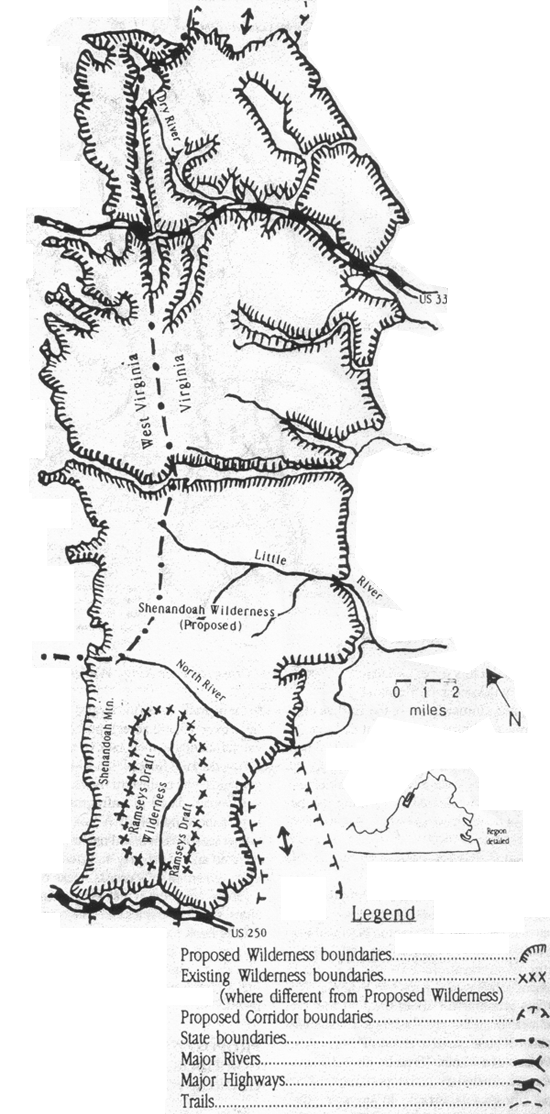
Figure 1: Proposed Shenandoah Mountain Wilderness/Corridor Complex.
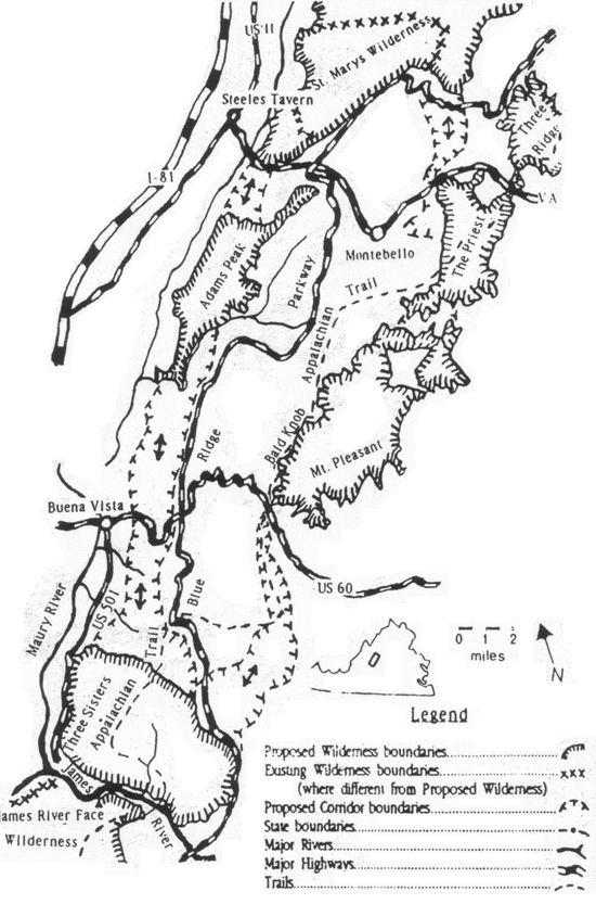
Figure 2: Proposed Blue Ridge Mountain Wilderness/Corridor Complex.
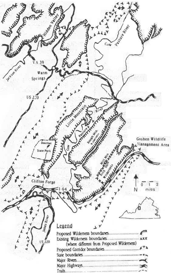
Figure 3: Proposed James River Wilderness/Corridor Complex.
(All three maps drawn by Gus Mueller)
| Wilderness Name | Size | Ranger District |
| George Washington National Forest | ||
| Laurel Fork | 10,900 acres | Warm Springs |
| Little River | 28,000 acres | Dry River |
| Ramsey's Draft Addition | 13,000 acres | Deerfield/Dry River |
| Mt. Pleasant | 8,500 acres | Pedlar |
| Skidmore Fork | 5,600 acres | Dry River |
| Kelley Mtn. | 7,900 acres | Pedlar |
| Three Ridges | 4,800 acres | Pedlar |
| Jefferson National Forest | ||
| Whitetop Mtn. | 4,500 acres | Mt. Rogers NRA |
Table 1. Areas Proposed for Wilderness by Virginia Wilderness Committee
ACKNOWLEDGEMENTS
The writer appreciates steadfast assistance in the field as well as many stimulating discussions with Crickett Hammond, Mike Jones, Steve Krichbaum and Gus Mueller. He is also grateful to Chuck Bailey for steering him to the rare flora of the Mt. Pleasant Area and to Brenda Vest for drawing our attention to Pond Ridge.
FOOTNOTES
1 An excellent treatment of old growth issues in the Appalachians is that of Zahner (Earth First!, Dec. 21, 1989).
2 Acreages on authority of George Washington planning staff
3 The character of old growth in this and other parts of the George Washington has been summarized by Mary Davis ("Old Growth in the East," Earth First! Journal, June 21, 1990)
4 Characteristically all this was done without scoping notices or an Environmental Assessment, a clear violation of regulations!
5 Based on the criterion of less than 1/2 mile of system roads per 1000 acres.
Bob Mueller is a retired NASA scientist who now works wit Virginians for Wilderness and PAW.