|
|
|
Esopus Valley flood
Sunday, April 3 2005
Recent heavy rains and snowmelt tested the limits of the Ashokan Reservoir's containment technology as it had never been tested before, and by this morning its engineers were allowing massive amounts of water to flow out into its only drainage aside from the thirsty throats and drains of New Yorkers: the lower stretch of Esopus Creek. The Esopus is the defining water body in the wide agricultural valley below our house; in order to get to the heart of Old Hurley, the NY Thruway, Kingston, Rosendale, or New Paltz, we are forced to cross it. But today we couldn't get anywhere near it, as a massive muddy arm of the creek had jumped its banks several miles upstream and inundated the lowlands on the west side of the Esopus Valley.
This west side is defined by a marked change in slope from gently-rolling flatland to steep mountainsides and occasional sharply-defined cliffs. Directly at the base of these cliffs runs Hurley Mountain Road, the main north-south artery of the Esopus Valley west of the creek itself. Long stretches of Hurley Mountain Road were dry, but there were parts that dipped below the level of the floodwater both north and south of its intersection with our road, Dug Hill Road.
This morning one of our friends from Eagle's Nest Road came to our house and announced that we were effectively isolated together from the rest of the world on an island. This wasn't strictly true, since we could still make it to Woodstock by going the other way up Dug Hill Road. But to get to Kingston would have required a massive detour involving distant roads we almost never use. Even State Route 28, the main artery connecting the central Catskills to civilization, was blocked.
At around noon I took the dogs down to Hurley Mountain Road to see the flooding for myself. The first thing I noticed was that Wynkoop Road, our main route to Hurley, Kingston, and 209, was blocked not far from its intersection with Hurley Mountain Road. From the looks of things, it this wasn't the only place where water crossed it. Further to the north past Eagle's Nest I saw that Hurley Mountain Road itself was blocked by this same arm of water, though it was shallow enough for people in four wheel drive vehicles to ford it, something they tended to do at high speed. Either this was because they were reveling in a novel justification for all the money they'd been spending on fuel. Or else they feared they'd lose traction half way across in the slick agricultural mud.
Going south on Hurley Mountain Road, I saw that the cluster of houses near the Dug Hill Road intersection were all suffering some sort of flooding, with water up to the clapboards of some of the buildings.
Hurley Mountain Road was "closed" at its intersection with Canary Hill Road, but I continued on between the cones to where the road crested a hump and plunged downward, soon vanishing beneath the swirling brown currents. I stood there at the edge of the water and looked as far as I could down the roadway but I couldn't see where the road came back out from beneath the flood. This was the definitive end of ground transportion in this direction.
At around 5pm Gretchen and I returned to Hurley Mountain Road to see if the flood levels had changed. Interestingly, they'd increased in some places and actually gone down a bit in others. For example, now there was a place where floodwater was actually crossing Hurley Mountain Road just south of the intersection with Dug Hill Road (it was so shallow we drove through it in the car). But at the place where Hurley Mountain Road vanished below the currents, the water was somewhat lower than I'd seen it this morning and had left a deposit of fine silt.
We lingered for awhile here at the site of the flood's greatest taunt. Occasionally burly trucks would rumble up, confident that they'd be able to ford, but then take one look at the water stretching off to the horizon and they'd make a U-turn.
Eventually we were joined by a plump high school kid carrying two cameras. I could tell that he was having one of the most exciting, delightful days of his brief life. He told us that State Route 28 was closed and that the State Police barracks on US 209 "is an island." He'd been driving everywhere he could around the flood and had good sense of its size. According to him, from one vantage point, "[The Esopus Valley] looks like the [Ashokan] reservoir."
He'd heard that this is a 100 year flood, which would mean that this is probably the first time such a flood has happened since the construction of the reservoir. "There's not going to be any school tomorrow," he said with delight, as if somehow this news might also make us happy.
I remembered how exciting floods had been for me when I'd been his age. I'd loved the way they gave the ignorant practical lessons in topography. As for this flood, I was finding it plenty exciting, but I've seen so many crazy things that it seemed well within the realm of plausible, unlike (say) September 11th, 2001. Also, I've only been living in this area for two and half years and I don't really know what to expect from the Esopus. I've been somewhat dubious of the people living in houses on the broad Esopus Valley bottom, but I'd come to assume that, as a glacial valley oversized for the creek it contains, it must not have much of a floodplain. Today served as a bit of corrective data for that assumption.
With Hurley Mountain Road reduced to just three miles of driveable roadway serving as it did as sort of the eastern edge of the knowable universe, our usually-familiar landscape felt unusually restricted, as if it really had become an island. So we decided to try to see other parts of the flood beyond what could be accessed on Hurley Mountain Road. We headed out to the other end of Dug Hill Road, some five miles away, and eventually found our way to State Route 28, which we drove as far east as we could. But well before we got to a place where we could see any floodwater, we enountered a police blockade and were forced to turn around. Since we were in the area we took the dogs for a brief hike at Onteora Lake, where water levels were higher than I'd ever seen them.
Originally there'd been a plan by Ms. Eagle's Nest to throw a birthday party tonight for her husband. But with the flood throwing such a monkeywrench into local transportational logistics, she decided to have just a little "intimate" gathering for the people who could easily make it. Though we didn't want to, this meant we were sort of "on the hook" to come. Making matters worse, power had been shut off to all the houses on Eagle's Nest due to flooded transformers, so it would be cold and candlelit.
Anticipating the bigger party that had originally been planned, Gretchen had prepared a dessert called a "trifle," because Mr. Eagle's Nest had told her that he used to like them back when he was a kid in New Zealand.
We showed up about an hour before sunset and found a very small party comprised of the Eagles Nests and three guests, one of whom Gretchen immediately found unbearably annoying. Mr. Eagle's Nest, who is often annoying anyway, was especially so tonight, finding cause to critique Gretchen's trifle as not being like the ones he remembered as a kid. Somehow, though, we sat around and made the best of the situation for over an hour before saying we had to go.
In this map, north is at the top and south is at the bottom and a mile is about three quarters of an inch. Floodwater is shown in light blue and purple spots are places where I took the following photographs.
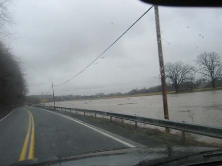
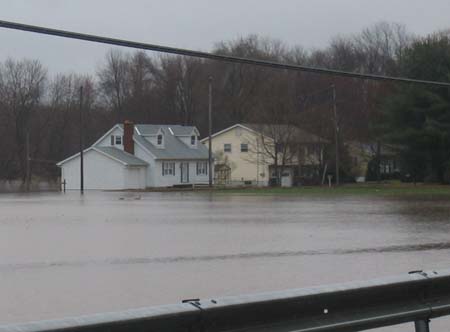
Flooding on the Esopus Valley a mile south of Old Hurley at noon today.
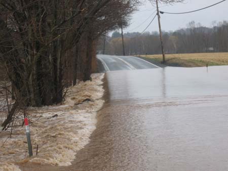
Flood water crossing Wynkoop Road a half mile west of Old Hurley.
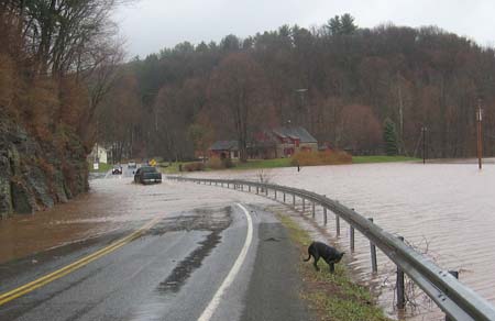
Eleanor explores the roadside near a spot along Hurley Mountain Road a half mile north of Wynkoop Road. At this point trucks were still fording here.
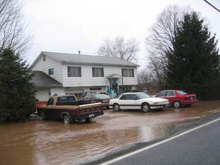
Flooding in a Hurley suburb just west of Old Hurley on the Esopus Valley bottom.
A local mechanic's humble garage is flooded a couple hundred feet south of the Dug Hill Road intersection on Hurley Mountain Road.
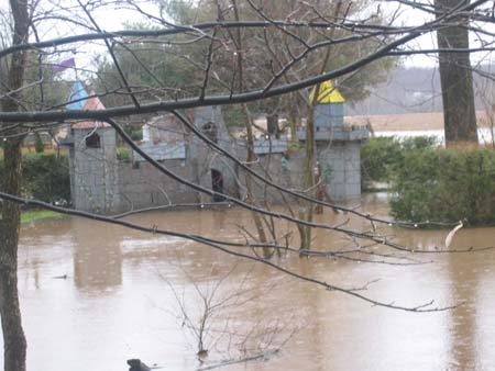
A child's outdoor castle is flooded further south down Hurley Mountain Road.
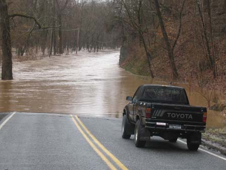
Impossibly deep floodwaters impede all traffic southward on Hurley Mountain Road a half mile south of the Dug Hill Road intersection.
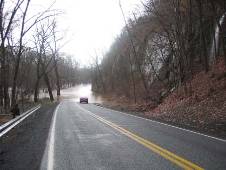
Later at 5pm Gretchen and I returned to see the flood waters. Here the car is parked at the southernmost limit of travel down Hurley Mountain Road. You can also see a waterfall coming down off the cliffs to the right.
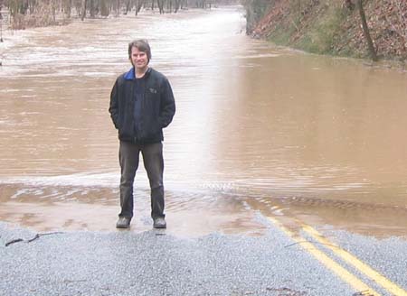
Me.
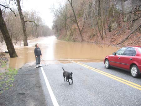
Gretchen with Sally.
For linking purposes this article's URL is:
http://asecular.com/blog.php?050403 feedback
previous | next |