|
|
|
the big walk
Friday, October 4 2013
Despite the dead deer lying near it, today I attempted to use the Lower Chamomile Trail to cross Dug Hill Road near the bus turnaround. On the way down, Ramona suddenly started running with incredible speed back down the trail to the house. I looked down to see where she'd just been standing and saw a cloud of Yellow Jacket hornets boiling out of the ground. I don't know what it is about Ramona and hornets, but I think part of the problem is this particular year: it's been a good one for hornets for some reason.
Further down the trail, Ramona rejoined us and it was Eleanor and not Ramona who expressed interest in the dead deer. Someone, maybe it was Ramona or maybe it was a Coyote, had slit open its skin to reveal the yummy parts within. If Eleanor was going to spend the day picking at the deer instead of coming with me and Ramona, I wasn't going to cross Dug Hill Road. So instead I went down to the bus turnaround to look for human artifacts (which I expected to see in the form of brass shells from spent ammunition). But then Eleanor came running up; evidently the idea of going for a long walk was more enticing even than a go at an unlimited salad bar of deer meat.
We crossed Dug Hill Road, crossed that well-developed lower trail, and then continued uphill through the forest until we came upon some sort of trail that led up a narrow ramplike valley with a band of beautiful cliffs high on the hill to the northwest. After crossing a divide, we found ourselves in a wide forested valley containing a small creek. The north wall of this valley was so steep that I couldn't climb it without also using my hands (a task made somewhat difficult by the fact that one of my hands held a ceramic New Yorker coffee mug and perhaps a bag of Red Rose tea). But climb it I did, eventually arriving at a line of 20 foot stone cliffs. There were a number of ways up through the cliffs, though for the most part they were of the 90 degree variety. Above the cliffs was a plateau, and from its edge, the panoramic view southward was astoundingly gorgeous. I could pick out an unexpected line of small hills rising in the light web of haze in the lowlands between where I was (about 650 feet above sea level) and the next real highlands, the Shawangunk ridge.
Just beyond the escarpment edge, I noticed a large clearing in the forest and could see a building that looked like some sort of semi-official garage. I walked out into the clearing and could see that to the east was a house that had been built on the escarpment's edge, probably to take advantage of the view. I'd seen this house before from the Gulleys Trail and I knew that it was connected to Eagle's Nest Road via a very long driveway. Perhaps that garage contained the equipment necessary to clear that driveway in the winter time.
Not wanting to be noticed in case someone was home, I slipped back into the forest, following a ramp slightly downhill to the west. When I'd made some distance, I began whistling for the dogs, which I'd lost when I'd begun climbing the cliffs. Eventually they reappeared; had they not I would have waited for them a long time.
I kept encountering unexpectedly beautiful things on this walk. For example, soon after being reunited with the dogs, we came upon a creek at the spot where it had begun cutting a narrow sheer-walled gorge in the bedrock. Ramona was so hot and thirsty that she immediately dove into the plunge pool at the bottom of the falls that marked the beginning of the gorge. (Though there was almost no water going over those falls.)
We made it to a well-maintained logging road that seemed to be going in the general direction of where we needed to be. But had it been going in precisely the right direction it would have quickly dumped us into Englishman's Gorge (the gorge just northeast of Dug Hill Road near our house). Instead it carried us northwestard on the gently-rolling plateau. I'd brought my GPS Device (an old Magellan Explorist 210) which quickly demonstrated its complete worthlessness. Not only did it fail to get a lock on the requisite number of satellites through the thin forest canopy overhead, but its compass feature failed too. No matter where the device was aimed, the on-screen arrow always pointing at the top of the device. A magnetized paperclip would have been a better navigational tool than it. Had I had a real compass, I would have known this logging road wasn't proceeding westward enough. Had the sun been out, it could have provided some additional navigational information. But it was mostly hidden behind clouds. With a few exceptions, in most of the places I hike the terrain itself serves as a navigational aid. But the terrain here was too flat to provide any guidance. And, since I was on a plateau through which the divides for disparate watersheds run, even if I were to discover a creek, there was a possibility that its downstream would take me out to Route 28 to the north.
And so we continued walking down that road. Somewhere along the trail I saw a pair of Sassafras trees, a species I have never seen in this region (it turns out that we're at the very edge of its range).
After covering a considerable distance on that logging road, we came to a place where the landscape had been somewhat hollowed-out by a mid-scale bluestone minining operation. This gave me some encouragement; surely if bluestone mining had happened here, there must be a nearby road to facilitate the movement of large trucks. But then the logging road seemed to bend more towards the north and I decided it was best to abandon it. So I headed more in what I felt was a westerly direction. This decision was soon rewarded by general falling away of the topography, suggesting I might be leaving the plateau. Eventually I came upon a creek full of water, but it was so lazy that it was difficult to determine which way it was flowing. When I found the tiny rapids indicating southward flow, it was a relief that I hadn't yet walked into a region where downhill would take me away from home.
Not long after I crossed the lazy creek, I could see through the trees that I was coming up on a road. It was Dug Hill Road, which came as something of a relief, though it was a little surprising that I hadn't heard any vehicles driving on it. Had the rapture happened? I soon determined that the place on Dug Hill Road where I was emerging (41.940052N, 74.118404W) was about a mile to the north of home, at the place where there are a number of abandoned buildings where Gretchen likes to dump the field mice we trap in our no-kill mousetraps. Just south of there is a house that has erected a couple iron sculptures near the road, one of which looks like a spider web made of rebar. I didn't want to walk in the road, so I had the dogs follow me parallel to the road southward, across the driveway of the people with the spider web sculpture. At that point I figured I'd encounter less civilization on the other side of Dug Hill Road, so I had the dogs cross. We passed the house with the permanent Tyvek (41.937899N, 74.117943W) on a low ridge in the back, though a guy in a large black American car seemed to be looking directly at me as he pulled in, and I was wearing a bright red shirt. So I hurried on, calling the dogs whenever they seemed distracted. For the most part they seemed to get that these were unusual circumstances and they did their best to keep up with me (though there was a brief chipmunk mining operation attempted by Ramona).
There's something kind of post-apocalyptic about running through the narrowest parts of someone's yard in an effort to get through undetected. Thankfully, I didn't have to do much of that; most of what I was doing was hiking through unfamiliar forest, sometimes passing interesting human artifacts. One of those was a hillbilly workshop with some wire spooled through the forest to supply it with power. Just beyond that was a large and beautiful raised-bed garden.
Eventually the dogs and I hiked into the familiar territory of first Lorenz Road and the Reichel Road. We crossed Reichel at an unfamiliar place, and just south of it I found a large bluestone boulder ontop of which someone had placed a bunch of quartz crystals (as well as some other crystals that were smoky brown in color). And a little beyond that, I found a small weathered statue of Buddha tossed unceremoniously into the bushes. It's actually a fairly long hike from Reichel Road back home, and, because it goes through flat plateau terrain, it's easy to get lost or turned around. And though most of the forest I passed through was unfamiliar, eventually I saw a stump that I remembered. And then soon enough I was on the Farm Road and then home. The whole walk had taken about two and a half hours. Here's a rough drawing of the entire route, which is based on a correlation between topographic landmarks and what I saw on the ground:
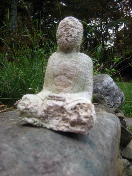
The Buddha I found. Later I put it in the greenhouse basement.
This evening I made myself a delicious meal of pasta and red sauce. Gretchen had stockpiled a bunch of hippie pasta containing rice or whole wheat, so instead I hit the topshelf pasta collection, using the Riccioli from Fairway Market. I put fresh hot pepper from the garden into the sauce to give it a little zing. I also added some semi-rotten homegrown tomatoes, which worked surprisingly well.
For linking purposes this article's URL is:
http://asecular.com/blog.php?131004 feedback
previous | next |
