|
|
|
grouting and kratom dysphoria
Tuesday, July 28 2020
At around 4:00pm, I was feeling a little miserable from having drunk a bit too much kratom tea (beginning at around 11:00am this morning). But I found switching from sitting at my desk to the more menial work of grouting the tile I'd installed yesterday distracted me from my dysphoria. That grouting (and associated cleanup) took only a little over an hour. And then I started feeling dysphoric again. I lay down in the bed and tried to watch YouTube videos, gradually becoming sleepier and sleepier. And then Gretchen said that Powerful was done making dinner, so I joined them out on the east deck. I was ravenously hungry, but after eating two servings of the red bean & broccoli curry stew, I felt like my stomach had hit a wall. This forced me to leave dinner early and retreat back to the upstairs bedroom.
Later at around 9:15 pm, I went up on the solar deck to look again for Comet Neowise. I was looking in exactly the right place to see it, but either the sky wasn't dark enough (it was cloudless, but there was still illumination in the west, and the quarter moon had waxed since I'd seen it yesterday) or my eyes lacked the dynamic range. I tried assisting my eyes with a pair of binoculars, but they actually seemed to have less light-gathering power than my eyeballs.
Using the Johns Hopkins Coronavirus Map, I've been gradually tracking the progress of the coronavirus as it fans out across the country. As I've mentioned before, I have a good sense of the United States "confirmed infection" map, where the darkest color is a saturated red and represents any county with more than about 320 confirmed coronavirus infections. For a long time in the spring, the red zones on the map were the Northeast Corridor, southern Florida, the Chicago area, the Detroit area, the New Orleans area, and Southern California. In recent months, the southeast and southwest of this country have gone nearly completely red. And a few days ago the last county in southern Florida (Glades) turned deepest red. Meanwhile in the southwest, there is now only one non-solid-red county left in Arizona, Greenlee.
As I had in the past, I've been focusing on deep red corridors (or lack of deep-red corridors) linking agglomerations of deep-red counties to other agglomerations of deep-red counties. For a long time, for example, the deep red counties of most of Florida had no deep red counties connecting them to the mass of deep red in the rest of the deep south. But then, about a week ago, Cook County, Georgia turned deep red, creating a corridor linking the bulk of Florida to all the urban areas of the Southeast. At this point, Alabama, Mississippi, Louisiana, eastern Texas, and the Atlanta area are one big interlinked mass of deep red with only occasional island counties of lighter colors. They link to another large mass of deep red counties in the Carolinas only through Habersham County, Georgia (in the north) and Tatnall and Emanuel Counties, Georgia (in the south), though those two southern-Georgia Counties only recently made their connections. For some reason, there are few east-west coronavirus corridors across Georgia.
While all that is going on, all the deep red of the American Northeast Corridor has had trouble making its way south through Virginia, stopping at Rockingham County (just northeast of Augsta County, the one I grew up in) in the west and just south of Richmond in the east. But there are north-south corridors gradually forming every other county across the bulk of Virginia. The first of these to connect the southeastern coronavirus zone with the coronavirus zone of the Northeast Corridor will probably involve Sussex County, Virginia, and Northampton County, North Carolina. When those two counties turn deep red, the eastern seaboard will become one big interconnected red zone.
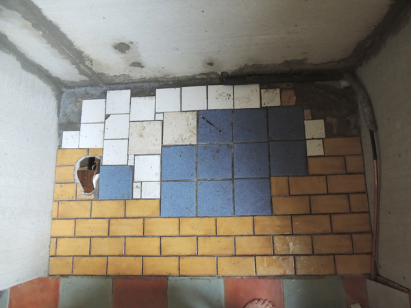
The tile before I grouted it today. It looks a little like a design by Piet Mondrian with the crap tiles that will be hidden by the tub.
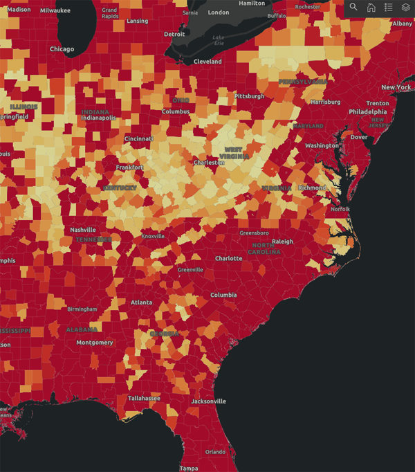
The coronavirus map in the Eastern United States as described above.
For linking purposes this article's URL is:
http://asecular.com/blog.php?200728 feedback
previous | next |